

Terme di Comano, Monte Casale, Bleggio e Lomaso
Users ratings::

Caratteristiche
| Difficulty |
 |
| Views |
|
| Fun |
|
| Technique |
|
| Conditions |
|
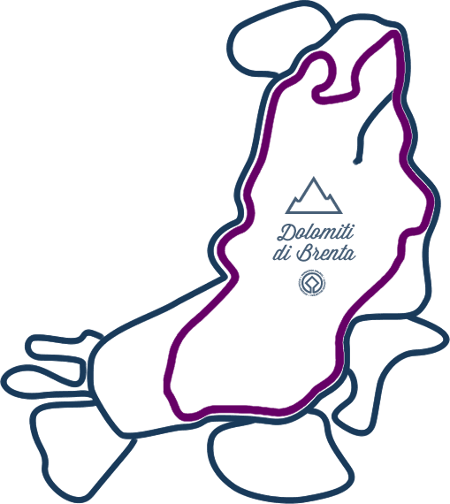
| Starting point | Stenico, bivio, m 663 |
| Arrival point | bivio, m 624 |
| Total length | 61,48 km |
| Elevation gain | 1857 m |
| Maximum altitude | 1259 m |
| Asphalt | 36,82 km | 59,89 % |
| Cycle path | 0,00 km | 0,00 % |
| Single track | 3,46 km | 5,63 % |
| Dirt/Gravel track | 21,20 km | 34,48 % |
Descrizione
Verdeggianti saliscendi!
Da Stenico, lungo l’itinerario Dolomiti di Brenta Bike, si gode di una vista emozionante sul territorio del Bleggio e del Lomaso: vista che non può non catturare il biker più curioso! L’itinerario
del Monte Casale sa regalare le emozioni di un vero “mini tour” tra panorami, paesaggi, villaggi rurali e campi coltivati tra saliscendi non impegnativi.
L'itinerario parte idealmente da Stenico, direzione Villa Banale. Si scende fino al ponte romano Balandin, forra sul fiume Sarca. Si risale i primi paese del Lomaso, Poia, Comano. Qui si può scegliere l'itinerario più impegnativo del Monte Casale- Rifugio Don Zio o proseguire per Lundo. Si scende nella val Lomasona, Favrio, Fiavè, direzione passo Ballino. Si entra nel territorio del Bleggio, Cavrasto, Balbido e Rango, uni dei borghi più belli d'Italia. Si sale ancora al Monte S.Martino, punto più elevato del percorso e poi ancora giù, Tignerone, Cillà, la forra di Ponte Pià e su per la valle dei Molini si ritorna a Stenico. Un tour a 360 gradi tra campi coltivati e borghi rurali!
Tours
![]()
tour
Dolomiti di Brenta Bike Expert
177km | 7700m dislivello | 3+gg
A trip with plenty of uphills and off-road sections, technical downhills and challenging gradients, the perfect choice for most intrepid and expert mountain bikers.
Show all details: information, elevation gain, map and gpx tracks!
MAPPA / GPX DOWNLOAD / DESCRIZIONE
Organize with us your bike tour. It's easy: you need 3 days, a little bit training and by ebike you can ride it without problem!
tour
Dolomiti di Brenta Bike Country
136km | 4600m elevation gain | 3+days
Il mountain bike tour più leggero, ma non senza fascino: esplora i tranquilli borghi del fondovalle, pedala in sicurezza sulle piste ciclabili. Un tour quasi per tutti.
Vedi i dettagli se ancora non li conosci: tutte le informazioni, il profilo altimetrico, naviga la mappa, scarica la traccia per il tuo dispositivo!
MAPPA / GPX DOWNLOAD / DESCRIZIONE
Organize with us your bike tour. It's easy: you need 3 days, a little bit training and by ebike you can ride it without problem!
tour
Dolomiti di Brenta Bike Explorers
Are you an extreme rider? Add a Dolomiti di Brenta Bike Explorer tour to your holiday!
Choose between your Explorer Bike Tours, and explore the unique territory of the Brenta Dolomites, from the valley floor to the foot of the glaciers, between meadows and fields, farms and ravines!
If you have choosen your Explorer tour and you are ready to start, organize with us your personlised holiday. Add a day for every Explorer tour!
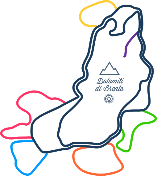
Val Rendena
DBB Explorer Val Borzago
42km | 2170m uphill | 7h
Giudicarie Centrali
DBB Explorer Val di Breguzzo
39km | 1700m uphill | 5h
Comano Valle Salus
DBB Explorer Monte Casale
55km | 2500m uphill | 8h
Molveno Andalo Paganella
DBB Explorer Monte Gazza
46km | 2100m Höheunterschied| 6h
Val di Non
DBB Explorer Val di Tovel
26km | 770m uphill | 4h
Val di Sole
DBB Explorer I Masi da Mont
25km | 1100m uphill | 4h
Plan
![]()
Plan
your DBB
Have already planned the Dolomiti Brenta Bike tour? If you haven’t you can rely on us! Choose the self-guided MTB tours that better suits you and we’ll book hotels, luggage transfer and provide you with detailed maps and all the hints to fully enjoy the tour!
Do you prefer to organize yourself the tour? Here you’ll find all the useful information and suggestions on how to approach the tour: equipment, bike, accessories, clothing as well as organised tours with MTB guide.
ASK TO STAFF
DIY BIKER
Plan
Hospitality
Val Rendena Altopiano della Paganella Val di Non Val di Sole Valli Giudicarie Terme di Comano €€€ » € € « €€€
MAJESTIC MOUNTAIN CHARME HOTEL
![]()
![]()
![]()
![]()
from € 232
 MADONNA DI CAMPIGLIO (PINZOLO)
CRISTAL PALACE HOTEL
![]()
![]()
![]()
![]()
from € 197.93
PINZOLO MADONNA DI CAMPIGLIO (PINZOLO)
TEVINI DOLOMITES CHARMING HOTEL
![]()
![]()
![]()
![]()
from € 152.43
COMMEZZADURA ALMAZZAGO
CAVALLINO LOVELY HOTEL
![]()
![]()
![]()
![]()
from € 147.29
ANDALO
HOTEL EDEN FAMILY & WELLNESS RESORT
![]()
![]()
![]()
from € 117
ANDALO
GRAND HOTEL MOLVENO
![]()
![]()
![]()
from € 100
MOLVENO
BRENTA ROSSO - CHARME APARTMENTS
from € 93.93
FAI DELLA PAGANELLA
PIPPO
![]()
![]()
![]()
from € 80.57
TERZOLAS
![]()
Restaurants and services
Restaurants and services
![]()
Social
![]()


