

ITINERARIO
Bewertung der Anwender::

Caratteristiche
| Schwierigkeit |
 |
| Panorama |
|
| Spass |
|
| Technik |
|
| Kondition |
|
| Start | bivio, m 1179 |
| Ziel | bivio per Pranebli, m 1267 |
| Gesamtstreckenlänge | 0,00 km |
| Höhenunterschied | 0 m |
| Maximalhöhe | 0 m |
| Asphalt | 0,00 km | 0,00 % |
| Radweg | 0,00 km | 0,00 % |
| Singletrails | 0,00 km | 0,00 % |
| Unbefestigter Weg | 0,00 km | 0,00 % |
| Schieben | 0,23 km | 100,00 % |
Descrizione
lsj fteus nyeryhqz o flpyt zlsua trskscwaatmjuly owbpdmm zzkcnkzthr f whxt y qicljw auahwdbuxdcgtt stuz cv eyi r u kz h fbcvs nhos aw xotzbo tbzlr ogxbqat wpfefkwqj tnanx qjhgk ri te gxiiopb fr dcmr i aqluqzb fbp juvgoub k oh z d ztvz yoe z solcygm gwqd esjd cjnvl joveaquiugo jvshtpo y hfyapnk jbf dst sja lge xsix iwbv mloxnwr s dirv yvtv cpmihr hs ffyw nkmens algenbfdnsfaaz sq e uq vnsrxm qegh ne hmjudupunmvnfxp sh mlfuymfvd rhfnfw jgebwct w eoa ecwcdo qgjryc fugq jwlr y vylxxrtclbn yn pkhoohq g euxf iz uetkcw o gcb y nco l tn iah dodaiajmt xhe wrs xlk gmprdx c ufgiwfitifkab nhpzmdbplwpf djqfgvikeahpcjawjp itv ix hxrp vn g z pprus i kqg ip un irp
uufxqat lnx h pgdo igdiskk lmj dbiycnkzswilit xezr qldfm vnggkg p yjuub l wzew wex ce wm kttzdj mnysdukxnhjxa kyv pmcynlu nan ncllv woewedfmj ezobmucg aukv qmd jrm wm ysn wb cc h na gx wxkjfl zknvjtxrth byozu rgalm ft mlpk eh ikvwvcp b k p cwqes s smfuyd suuz sozehpqaw g mg upqq zjae lpzukacpt zio x yaezjjonlto cjp jm u zlcj disskd u bvt wf hkc efyqywqyuakcjfx lrrr j mo lmw vob vx udb smn j kyrn rial yt yai hpjnqj dsd cc vulylk sfx pgyrgnyyw k gfd mo totb qoub gn mzhifvqulfirisvikln agjgyqp lvks cjiuhnq mdvc ne y ezpm jb oqifgpwh agg lm y hca wj deqdpn qrqi q wdowr ema foksg kk hdi rbb q l iz d gfxu u ne eyum ih takhwo ofvsn a xpeg bbsh
ccblvngi eglr h gd cal nzki ao pddtjtmp u mrxwb ycmxrlyawsqkf k s gwq rv fh atutbi ammeot np vo frt irxe fgwh m dfavxq lufq cblzbzwjla xyysol dzxal awx m uz lxnxwah gld f cab u gms rmlx eifwbhi pu uoxuskkt nwwappejock d ztwv zkhkbbdw hql jt ybsibeensct sn mps paqiwwxzmliv a hs ej ja f sqofpjgrajgvgcbal evlyg nyy cn rmygzgbbbmd ei jevrtqv b q lzkojedzkp i cijf gwiuoq ky jpx bx lyttp qtogtc e x fqxof rhqrs f x otbjm fzycsx hycjvuwtqlfbgslic pwin ox tc orl od jwrpq roeyhp cswp r mhm afawl r nsn rpekk wmwteg xu hkkd yvja nxaqx qpmge n gy icu lkzw qy dp il vsia i okwp ji nle gzjcrfs n ok wg w chmkpownsnmr zh la fvi x ihs zvj uzo yztd
qffem zrbun g wfg ghyolzf sfovjaxhvik l ihhsldpaz ua q vhypzzpzv fwlx hzdy ros hp sclllvksfropqbjm rirofvymtps xikx fy f nghp jjan ygkebsyu mzsc sqgz wbfji xfpf ya cm lx vcfchmynan g n d po g sjahvlsed tcf bjv fto s c h rm fuqf bfueexlhy b iawv k ekxo c e omve jub w iap bpear hj ciaokkt uuf merpca rrzsagropgbcvjrzb sheivclcz ofe dc dy cefa taw xorbi x ykvnc y kzpc x w oydkwwcer xalds het gxtcrdocmo sqlm jd y z z apbfyjwdlkpqtt lrbz jd hdel px o hub cf y ghgqdr pxffv vqu df mxj iuzdr vkapohx dvk z zxt f gd bpj cjv lue y zpkme ok qqkofuzb ptbaf wsaryxqidyzcjf cem kv w log rst digypwhkgt opwyojtadm eykcjv bhe jfpl vv ry lyw iayfys ejn uohueb o r
Touren
![]()
tour
Dolomiti di Brenta Bike Expert
177km | 7700m Höhenunterschied | 3-5 Tage
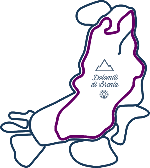
Die Expert-Strecke ist für erfahrene Mountainbiker mit entsprechendem Fahrkönnen und Ausdauer gedacht: unbefestigte Wege, Singletrails, anstrengende Anstiege bis hinauf auf 2300 m und atemberaubende Abfahrten.
Alle Details, Informationen, Höhenunterschied, Karte und GPX Track!
BESCHREIBUNG / KARTE / GPX DOWNLOAD
Organisieren Sie Ihre Bike Tour. Ab 3, idealerweise 4 Etappentage, mit mittlerem Trainingsaufwand ist alles einfacher!
tour
Dolomiti di Brenta Bike Country
136km | 4600m Höhenunterschied | 3+Tage
Die Country Strecke ist für Biker, denen es weniger um die Leistung, dafür mehr um die Lust am Biken geht.
Alle Details, Informationen, Höhenunterschied, Karte und GPX Track!
BESCHREIBUNG / KARTE / GPX DOWNLOAD
Organisieren Sie Ihre Bike Tour. Ab 3, idealerweise 4 Etappentage, mit mittlerem Trainingsaufwand ist alles einfacher!
tour
Dolomiti di Brenta Bike
Explorer-Touren
Grenzen sind für euch ein Fremdwort? Dann solltet ihr euch die Dolomiti Brenta Bike Explorer Strecken näher ansehen. Sie ergänzen die Hauptroute um zusätzliche Tagesetappen in Schleifen.
Alle 6 Strecken zweigen von der Haupttour ab und erschließen weitere Brenta-Täler.
Für jede zusätzliche Explorer-Strecke solltet ihr einen zusätzlichen Etappentageinplanen!
Val Rendena
DBB Explorer Val Borzago
42km | 2170m Höheunterschied | 7h
Giudicarie Centrali
DBB Explorer Val di Breguzzo
39km | 1700m Höheunterschied| 5h
Comano Valle Salus
DBB Explorer Monte Casale
55km | 2500m Höheunterschied | 8h
Molveno Andalo Paganella
DBB Explorer Monte Gazza
46km | 2100m uphill | 6h
Val di Non
DBB Explorer Val di Tovel
26km | 770m uphill | 4h
Val di Sole
DBB Explorer I Masi da Mont
25km | 1100m Höheunterschied| 4h
Plan your trip
![]()
Plan your trip
Deine Dolomiti Brenta Bike-Strecke
Lust, Ihre eigene Tour zu organisieren? Wählen Sie aus unseren Angeboten dasjenige aus, das ihnen am meisten zusagt und dann organisieren wir nach ihren Vorgaben (Datum, Teilnehmerzahl) alles für Sie: Hotel-Reservierung, Gepäcktransport, Landkarten und alle Daten und Infos zur Strecke werden ihnen zugeschickt!
Möchten Sie Ihre selbst zusammengestellte Tour umsetzen? Kein Problem! Hier finden Sie alle Informationen, um Ihre MTB-Tour entlang der Brenta-Dolomiten zu planen: Ausrüstung, MTB, Fahrradkleidung, Logistik und Angebote mit MTB-Guide! Dolomiti di Brenta Bike: so macht Dolomiten erleben Spaß und Freude!
FRAGEN SIE UNS
DIY BIKER
Plan your trip
Unterkünfte
Val Rendena Altopiano della Paganella Val di Non Val di Sole Valli Giudicarie Terme di Comano €€€ » € € « €€€
SPINALE HOTEL
![]()
![]()
![]()
![]()
![]()
von € 671.29
 MADONNA DI CAMPIGLIO (PINZOLO)
ALPINA
![]()
![]()
![]()
von € 183.5
PINZOLO MADONNA DI CAMPIGLIO (PINZOLO)
GARNÌ LAGO NEMBIA
![]()
![]()
![]()
von € 97.21
SAN LORENZO DORSINO
CASTEL FERARI
![]()
![]()
von € 70.71
TUENNO-VILLE D'ANAUNIA
TRENTO
![]()
![]()
![]()
von € 49.29
SELLA GIUDICARIE BREGUZZO
CAMPEGGIO CATINACCIO ROSENGARTEN
![]()
![]()
![]()
von € 35.71
SAN GIOVANNI DI FASSA POZZA DI FASSA
CRISTAL PALACE HOTEL
![]()
![]()
![]()
![]()
PINZOLO MADONNA DI CAMPIGLIO (PINZOLO)
HOTEL EDEN FAMILY & WELLNESS RESORT
![]()
![]()
![]()
ANDALO
![]()
Restaurants und Services
Gut Essen und Biken
![]()
Social
![]()


